Greg Asner is part of the Senior ECPA Fellows program that gathers experts from the western hemisphere to share latest research findings and collaborate on solutions.
No one knew the full extent of the damage until a research team from the Carnegie Institution of Science and Peru’s Ministry of the Environment used satellite imagery to map the damage. Their findings are published in Proceedings of the National Academy of Sciences.
Peru’s rain forests sit on top of a wealth of natural treasures, from oil and coal to gold. To get to these riches, miners destroy the forest and mountains that sit atop them. This could be devastating for the Earth, since these forests play such an important part in our ecosystem.
 Justin Catanoso, a journalist who just returned from touring the Peruvian rain forests with ecologist Miles Silman, thinks that saving these forests is an integral part of slowing the potentially devastating effects of climate change. One way we can do that, he said, is if richer countries work together on an international level to pay countries like Peru to leave these pristine and important forests untouched and stop the for-profit destruction of these forests.
His fear isn’t unfounded, according to the new paper. These miners are already destroying acres and acres of these precious rain forests. An article in The Verge described the process gold miners use: They create craters by digging a few meters and blasting the holes with pressurized water to clear away the soil, completely destroying the forest area.
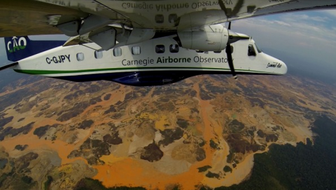
Asner and his team used a plane outfitted with Laser Imaging, Detection, and Ranging technology to survey the area. This kind of imaging actually uses lasers to scan areas and creates 3-D diagrams of the land. This kind of satellite imaging is much more sensitive than older kinds, and revealed many more mines than scientists were able to detect in the past.
 View Map